
Date: Pre-1929
Boundary: District designations as they appear in early census records
Date: 1930-1975
Boundary: Landward districts were created as a result of the Local Government (Scotland) Act 1929. They were formed by grouping parishes outside of Burghs (areas known as Landward) into districts with elected councils.
Date: 1975-1996
Boundary: Region and district designations as a result of the 1973 Local Government (Scotland) Act, with OPR parishes that fell into each district. The changes took effect on 15 May 1975, and were in place until 1996.
Date: Changes made as a result of the Local Government (Scotland) Act, 1889. Changes went into effect on 15 May 1891.
Summary: Kirkpatrick-Juxta and Moffat (straddling border with Lanarkshire) were transferred to Dumfriesshire. Interior rearrangements for the parishes of Dornock and Kirkpatrick-Fleming.
Details:
Orders made by the Boundary Commissioners for Scotland under Section 49 of the Local Government (Scotland) Act, 1889. Orders shall come into operation for the purposes of School Board elections on the 1st day of February 1891, and for all other purposes on the 15th day of May 1891.
Affected Parishes:
Dornock
Kirkpatrick-Fleming
Kirkpatrick-Juxta
Moffat
Parishes of Dornock and Kirkpatrick-Fleming, County of Dumfries
The parish of Dornock had a detached part situated to the north of the main portion of the parish, and separated from it by an intervening portion of the parish of Kirkpatrick-Fleming. This intervening portion has been transferred to the parish of Dornock, and the main portion of Dornock has thus been united with its detached part.
Transferred from the parish of Kirkpatrick-Fleming to the parish of Dornock:
Floshpark - John Ramsay (Proprietor)
Scotsfield - John Ramsay (Proprietor)
Parish of Kirkpatrick-Juxta, County of Dumfries
The parish of Kirkpatrick-Juxta, which is shown on the Ordnance Survey maps as wholly in the county of Dumfries, was really situated partly in that county and partly in the county of Lanark. The parish was placed wholly in the county of Dumfries.
Transferred from the county of Lanark to the county of Dumfries (while remaining in the parish of Kirkpatrick-Juxta):
Whiteholm - J. J. Hope Johnstone (Proprietor)
Parish of Moffat, Counties of Dumfries and Lanark
The parish of Moffat, which was situated partly in the county of Dumfries and partly in the county of Lanark, has been placed wholly in the county of Dumfries.
Transferred from the county of Lanark to the county of Dumfries (while remaining in the parish of Moffat):
Harthope - William Johnstone (Proprietor)
Raecleugh - J. J. Hope Johnstone (Proprietor)
Annan
Royal Burgh: 1532
Small Burgh: 1929
Parish: Annan
Region (Before 1975): Dumfries and Galloway
District (Before 1975): Annandale and Eskdale
Dumfries
Royal Burgh: c. 1186
Large Burgh: 1929
Parish: Dumfries
Region (Before 1975): Dumfries and Galloway
District (Before 1975): Nithsdale
Langholm
Burgh of Barony: 1621
Burgh of Regality: 1687
Small Burgh: 1929
Parish: Langholm
Region (Before 1975): Dumfries and Galloway
District (Before 1975): Annandale and Eskdale
Lochmaben
Royal Burgh: 1447
Small Burgh: 1929
Parish: Lochmaben
Region (Before 1975): Dumfries and Galloway
District (Before 1975): Annandale and Eskdale
Lockerbie
Police Burgh: 1863
Small Burgh: 1929
Parish: Tundergarth
Region (Before 1975): Dumfries and Galloway
District (Before 1975): Annandale and Eskdale
Moffat
Burgh of Regality: 1648
Small Burgh: 1929
Parish: Moffat
Region (Before 1975): Dumfries and Galloway
District (Before 1975): Annandale and Eskdale
Sanquhar
Burgh of Barony: 1484
Royal Burgh: 1598
Small Burgh: 1929
Parish: Sanquhar
Region (Before 1975): Dumfries and Galloway
District (Before 1975): Nithsdale
See Parish Page Sources for all source information and links.
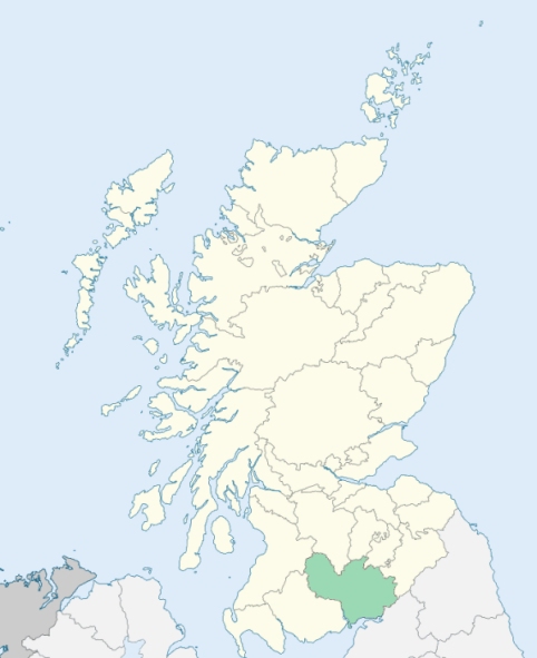
Location of Dumfriesshire
View more maps at Wikipedia