Fothergill, Fortingal
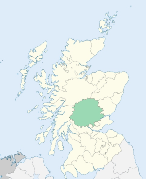
Fortingal: Fortingal is a very large parish occupying the chief part of the north-western division of Perthshire. It is bounded on the north by the district of Badenoch in Inverness-shire, on the north-east by the parish of Blair Atholl, on the east by the parish of Dull, on the south by the parishes of Kenmore and Killin, and a detached portion of the parish of Weem, and on the west by the parishes of Glenorchy and Appin in Argyllshire, and the district of Lochaber in Inverness-shire. The extensive district, which constitutes the main body of the parish, is naturally and comprehensively divided into three portions - Rannoch, Glenlyon, and Fortingal proper. The former constitutes the northern part of the parish, and the latter, jointly with Fortingal proper, a considerable portion of the southern part. (1867: The Imperial Gazetteer of Scotland, by John Marius Wilson).
Foss: Foss is situated on the south side of the river Tummel, toward the western extremity of Loch Tummel. (1867: The Imperial Gazetteer of Scotland, by John Marius Wilson)
Aulich, Balnald, Camghouran, Drumchary or Drumcharry, Fortingal, Innerwick, Keltneyburn, Killachonan, Kinloch Rannoch or Kinlochrannoch, Kirktown, Rannoch
Chesthill, Dalchonsie, Dall, Dunalastair, Garth House
(1) The land marked on the Ordnance Survey maps as common to the parishes of Blair Atholl, Fortingall, and Logierait was divided between the first two of these parishes. The part north of Allt Sleibg was annexed to Blair Atholl. See affected properties and landholders. (1892: Boundary of counties and parishes in Scotland as settled by the Boundary Commissioners under the Local Government Act, 1889, by Hay Shennan)
(2) The parish of Fortingall had two detached parts:
1. Bolfacks, on the south of the River Tay, west of Aberfeldy
2. Loch Lyon, at the head of Glen Lyon
(a.) Fortingall detached No. 1 was transferred to the parish of Dull. That part of Kenmore situated at Drummond Hill, which lay north of the watershed, was annexed to Fortingall.
(b.) That part of Kenmore detached No. 4 which lay in the basin of the River Lyon was also annexed to Fortingall.
(c.) So much of Weem detached No. 4 as lay in the basin of the River Lyon was annexed to Fortingall, and so much of Weem detached No. 9 as lay in the basin of the River Lyon was also annexed to Fortingall. Fortingall detached No. 2 was thus united with the main portion of the parish of Fortingall.
(d.) Logierait detached No. 3 and Logierait detached No. 4 were annexed to Fortingall. See affected properties and landholders. (1892: Boundary of counties and parishes in Scotland as settled by the Boundary Commissioners under the Local Government Act, 1889, by Hay Shennan)
PRE-REFORMATION GOVERNANCE:
POST-REFORMATION GOVERNANCE:
The ancient church of Fortingal was dedicated to St Cedd, in whose honour there was held here a yearly market called Feill Cheid (Cedd's Fair). In later times the church dedication was changed to the name of St Katherine, and the fair was held on her day. In 1585 the parishes of Glenlyon and Kilchonain, or Kinloch in Rannoch, were united to Fortingal. They were both disjoined again in 1845.
Disjoined Quoad Sacra Parishes:
Braes of Rannoch. The church was built in 1855, and the parish was disjoined from Kinloch Rannoch and Fortingal, 16 March 1885.
Foss. A parliamentary church was built here in 1830. The parish was disjoined from Fortingall and erected 11 June 1845.
Glenlyon. Previously called Killinlynar, and in recent times Innerwick, or Inverbhaic. The church of Glenlyon was dedicated to St Kinnera. In 1585 this parish was united to Fortingal and Kilchonain in Rannoch, but was proposed to be again disjoined by the General Assembly, and was referred by Parliament, 11 September 1639, to the Commission to be granted for the Plantation of Kirks. It was erected as a parliamentary charge in 1829, and the parish was disjoined from Fortingal and Weem 11 June 1845. At Kerrowmore in Glenlyon there was a chapel of St Breandan.
Includes ministers, licentiates, assistants, readers, and clerks.
Fortingal (QO)
Braes of Rannoch (QS)
Foss (QS)
Glenlyon (QS)
(1928: Fasti Ecclesiæ Scoticanæ, by Hew Scott, D. D.)
Parish registers turned over to the Registrar-General, as a result of the Registration of Births, Deaths, and Marriages (Scotland) Act of 1854. The letters B. D. and M. indicate Births (or Baptisms), Deaths (or Burials), and Marriages (or Proclamations of Banns) respectively. Numbers indicate separate volumes or books. Note: These records are by no means complete or without damage; consult the Detailed List of the Old Parochial Registers of Scotland (1872) to learn more about the condition of the records.
| OPR and RD Numbers | |||
|---|---|---|---|
| Date Range | Name | Number | Type |
| 1748-1854 | Fortingall | 355a | OPR |
| 1830-1854 | Foss | 355b | OPR |
| 1855-1856 | Fortingall | 355 | RD |
| 1857-1874 | Fortingall | 355a | RD |
| 1857-1960 | Foss | 355b | RD |
| 1875-1968 | Innerwick in Glenlyon | 355a1 | RD |
| 1875-1968 | Fortingall | 355a2 | RD |
| 1893-1960 | Kinloch Rannoch | 355a3 | RD |
| 1961-1971 | Rannoch and Foss | 355 | RD |
| 1972-2003 | Rannoch and Foss | 382 | RD |
| 2009 | Perth and Kinross, Rannoch and Foss | 382 | RD |
| 2009 | Perth and Kinross, Fortingall | 384 | RD |
| 2009 | Perth and Kinross, Innerwick | 384 | RD |
| 2026 | (Fortingall) Perth and Kinross Council; Glenlyon and Loch Tay Community Council | ||
| 2026 | (Kinloch Rannoch) Perth and Kinross Council; Rannoch Community Council | ||
(2009: Parishes and Registration Districts of Scotland - Old and New, National Records of Scotland)
Local community councils (2026) are provided as a potential source of additional information for settlements within the original boundaries of the parish. (Source)
Statistics from informal and official censuses
Anderson, Cameron, Campbell, Dewar, Fisher, Forbes, Irvine, Menzies, Robertson, Stewart
Note: Names appearing in research materials, other than censuses. Simple names (First name, surname only) have been omitted unless they appear associated with large properties. All women's names, and men's names with occupations, military ranks, or peerage titles are included.
By the Reverend Mr Duncan M'Ara.
"The number of souls is 3914. There is every reason to believe, that the females are 600 more than the males. According to the best information that can be got, there are 487 children below 5, and 447 between 5 and 10 years of age. The number of tenants is 354, of crofters 105, of cottagers 250; of men servants 152, of maid servants 289. Among the cottagers are the handy-craftsmen, who serve the country. Some, but not many, have emigrated to America. The most of them have gone southward to the towns. There are no Papists, Seceders, nor Jacobites, although the latter were formerly numerous. There are about a dozen Episcopalians.
The people here are as industrious, pious and charitable as any of their neighbours, or perhaps any in the kingdom."
(This section contains excerpts, at times restructured or paraphrased, from an article appearing in Statistical Account of Scotland, Sir John Sinclair, 1791-1799)
Primary Sources:
Statistical Account of Scotland (1791-1799), Volume 2, p. 449
New Statistical Account of Scotland (1834-1845), Volume 10, p. 527
See Parish Page Sources for all source information and links.