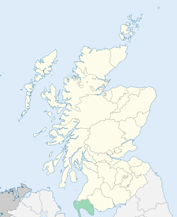
Mochrum is a parish on the southern coast of Wigtownshire. It lies along the upper part of the east side of Luce Bay, and is bounded elsewhere by the parishes of Old Luce, Kirkcowan, Kirkinner, and Glasserton. (1867: The Imperial Gazetteer of Scotland, by John Marius Wilson).
Alticry, Barrachan, Corhulloch, Eldrig or Elrig, High Glenling, Loch Head, Mochrum, Myrton, Port William
PRE-REFORMATION GOVERNANCE:
POST-REFORMATION GOVERNANCE:
The church of Mochrum belonged to the Priory of Whitern (Whithorn). This church was rebuilt in 1794. There was a chapel in the parish at Mertoun, and another at Chapel Finian. This latter was dedicated to St Finian of Clonard. Near its ruins was the Well of St Finian, and the place still bears the name of Chipperfinian (Tobar Fhiniain = St Finian's Well).
Includes ministers, licentiates, assistants, readers, and clerks.
(1928: Fasti Ecclesiæ Scoticanæ, by Hew Scott, D. D.)
Parish registers turned over to the Registrar-General, as a result of the Registration of Births, Deaths, and Marriages (Scotland) Act of 1854. The letters B. D. and M. indicate Births (or Baptisms), Deaths (or Burials), and Marriages (or Proclamations of Banns) respectively. Numbers indicate separate volumes or books. Note: These records are by no means complete or without damage; consult the Detailed List of the Old Parochial Registers of Scotland (1872) to learn more about the condition of the records.
| OPR and RD Numbers | |||
|---|---|---|---|
| Date Range | Name | Number | Type |
| 1720-1854 | Mochrum | 892 | OPR |
| 1855-1971 | Mochrum | 892 | RD |
| 1972-2004 | Mochrum | 873 | RD |
| 2005-2009 | Dumfries and Galloway, Mochrum | 873 | RD |
| 2026 | Dumfries and Galloway Council; Port William Community Council | ||
(2009: Parishes and Registration Districts of Scotland - Old and New, National Records of Scotland)
Local community councils (2026) are provided as a potential source of additional information for settlements within the original boundaries of the parish. (Source)
Statistics from informal and official censuses
Anderson, Black, Brown, Davidson, Gibson, Henderson, Muir, Murray, Nicholson, Rutledge
Note: Names appearing in research materials, other than censuses. Simple names (First name, surname only) have been omitted unless they appear associated with large properties. All women's names, and men's names with occupations, military ranks, or peerage titles are included.
By the Reverend Mr John Steven.
"There is, perhaps, no country parish in the county that has increased so much in population as Mochrum for these last 20 years. The inhabitants, who now amount to 1400, it is certain, did not exceed half the number previous to that period. This increase has been almost entirely effected on Sir William Maxwell's estate, who, carrying on extensive plans of improvement upon the lands which he held in his own natural possession, had occasion to employ a number of additional labourers, and these happening to consist mostly of young, stout, newly married Irishmen, this prolific race soon contributed largely to the human stock.
No manufactures have yet found their way here; but Sir William Maxwell has been proposing to have one erected on some of his fine situations. The present number of mechanics, of every description, is about 20.
At Portwilliam stands a neat small village; the inhabitants of every description are about 210. In 1788 a small barrack-house was erected here for the accommodation of the military, and custom-house officers occasionally sent to prevent the landing of smuggled goods."
(This section contains excerpts, at times restructured or paraphrased, from an article appearing in Statistical Account of Scotland, Sir John Sinclair, 1791-1799)
Primary Sources:
Statistical Account of Scotland (1791-1799), Volume 17, p. 559
New Statistical Account of Scotland (1834-1845), Volume 4, Section III, p. 60
See Parish Page Sources for all source information and links.