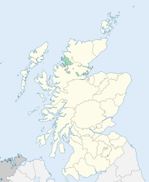
Fodderty is a mountainous parish in the counties of Ross and Cromarty. It is bounded by Kincardine and Kiltearn on the north, by Dingwall on the east, by Urray on the south, and by Contin on the west. (1867: The Imperial Gazetteer of Scotland, by John Marius Wilson).
Auchterneed or Auchterneid, Fodderty, Garve, Keithtown, Maryburgh, Millnain, Tollie
The parish of Fodderty had two detached parts:
(a) Fodderty detached No. 1 extended to 18,474 acres, and was almost surrounded by the parish of Contin.
(b) Fodderty detached No. 2, extending to 2,720 acres, lay to the south of the main portion of the parish, and was separated from it by a narrow strip to the parish of Dingwall.
Not only had the parish of Urray two detached parts in the county of Ross and Cromarty, but in addition part of the main portion of the parish was situated in the county of Inverness.
(a) Urray detached No. 1, containing 2,463 acres, was almost surrounded by the parish of Contin.
(b) Urray detached No. 2, with 38,561 acres, lay in Glen Orrin west of the main portion of the parish, being separated from it by a strip of Contin and a strip of Fodderty detached No. 1.
In dealing with these two parishes it was found necessary to effect alterations on the boundaries of the parishes of Contin and Dingwall. The only territory taken from Contin is the small portion of the parish lying to the south of the watershed between Strath Conan and Glen Orrin which was transferred to the parish of Urray. On the other hand, Contin received a large accession of territory, for there were transferred to it detached part No. 1 of the parish of Urray, and all of Fodderty detached No. 1 except the portion lying to the south of the above-mentioned watershed. See affected properties and landholders. (1892: Boundary of counties and parishes in Scotland as settled by the Boundary Commissioners under the Local Government Act, 1889, by Hay Shennan)
PRE-REFORMATION GOVERNANCE:
POST-REFORMATION GOVERNANCE:
The parishes of Foddery, Kinettas, and Glen Ussie were united about 1600.
Fodderty. In the parish of Fodderty there was a chapel of St Mary at Innis Ruaraidh.
Kinettas. The prebend of Kinettas in the Cathedral of Fortrose was held by the Chancellor of the diocese of Ross.
Glen Ussie. The ancient church of Glen Ussie stood at the village of Tollie. Its site is now under water, Loch Ussie having been much enlarged to supply water to Dingwall.
Disjoined Quoad Sacra Parishes:
Kinlochluichart. In 1825 a parliamentary chapel was built at the upper end of Loch Luichart. On 16 March 1864 the parish of Kinlochluichart was disjoined from Contin, Fodderty, and Urray.
Includes ministers, licentiates, assistants, readers, and clerks.
Fodderty (QO)
Kinettas (QO)
Kinlochluichart (QS)
(1928: Fasti Ecclesiæ Scoticanæ, by Hew Scott, D. D.)
Parish registers turned over to the Registrar-General, as a result of the Registration of Births, Deaths, and Marriages (Scotland) Act of 1854. The letters B. D. and M. indicate Births (or Baptisms), Deaths (or Burials), and Marriages (or Proclamations of Banns) respectively. Numbers indicate separate volumes or books. Note: These records are by no means complete or without damage; consult the Detailed List of the Old Parochial Registers of Scotland (1872) to learn more about the condition of the records.
| OPR and RD Numbers | |||
|---|---|---|---|
| Date Range | Name | Number | Type |
| 1735-1854 | Fodderty | 65 | OPR |
| 1855-1967 | Fodderty | 65 | RD |
| 2009 | Highland, Dingwall and Carnoch | 196 | RD |
| 2026 | Highland Council; Dingwall Community Council | ||
(2009: Parishes and Registration Districts of Scotland - Old and New, National Records of Scotland)
Local community councils (2026) are provided as a potential source of additional information for settlements within the original boundaries of the parish. (Source)
Statistics from informal and official censuses
Cameron, Dingwall, Fraser, MacDonald, MacGregor, MacKay, Mackenzie, MacRae, Ross, Stewart
Note: Names appearing in research materials, other than censuses. Simple names (First name, surname only) have been omitted unless they appear associated with large properties. All women's names, and men's names with occupations, military ranks, or peerage titles are included.
By the Reverend Mr Donald Mackenzie.
"There is for some seasons of the year, a very great want of industry among the inhabitants here. During the weeks of seed-time and harvest they exert themselves to a great degree; but during the remainder of the year, having no field for similar exertions of industry, they indulge themselves to a great degree in indolence and inactivity. The want of employment here, forces those who are industriously inclined, to go and find labour in the southern districts of Scotland; so that great numbers of both sexes, leave their homes in the months of May and June, and return again in November. The language generally spoken here is Gaelic, there being but two in the parish who do not understand that language well."
(This section contains excerpts, at times restructured or paraphrased, from an article appearing in Statistical Account of Scotland, Sir John Sinclair, 1791-1799)
Primary Sources:
Statistical Account of Scotland (1791-1799), Volume 7, p. 410
New Statistical Account of Scotland (1834-1845), Volume 14, Section II, p. 344
See Parish Page Sources for all source information and links.