
Plaidwerx


Features: Scottish Parishes » Historic Shires » Lanarkshire » Cadder

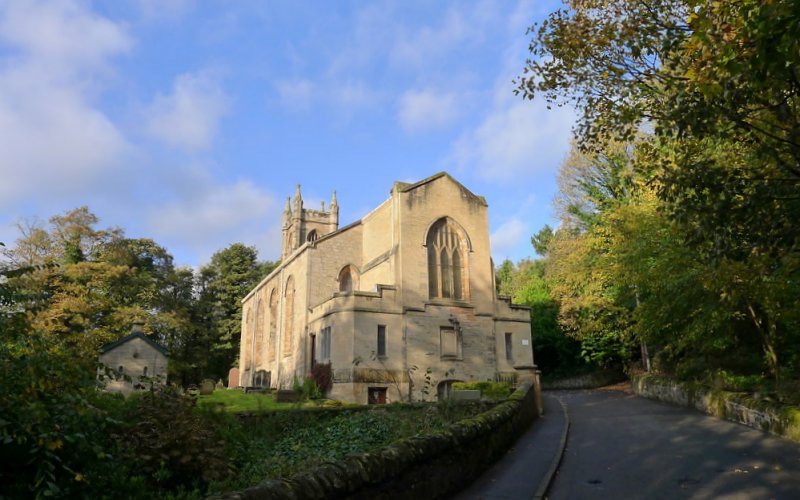
Cadder Parish Church by Tim Heaton
Cadder Parish Church © 2018, Tim Heaton

CADDER PARISH

TABLE OF CONTENTS


ALTERNATE NAMES AND SPELLING:

Calder


LOCATION

Location Description:

Cadder is a parish on the northern border of Lanarkshire. It is bounded on the north and north-west by Stirlingshire and Dumbartonshire, and on other sides by the parishes of New Monkland, Old Monkland, and Barony of Glasgow. (1867: The Imperial Gazetteer of Scotland, by John Marius Wilson).

Shire, District, and Region Timeline:

  • Shire: Lanarkshire (Before 1707)
  • County: Lanark (After 1707)
  • District: Under Ward (Before 1930)
  • Landward District: Ninth (1930-1975)
  • Region: Strathclyde (1975-1996)
  • Sub-Region: Dunbarton (1975-1996)
  • District: Strathkelvin (1975)

Burghs:

  • Name: Bishopbriggs
  • SmallBurgh (1964)

Cities, Towns, Villages, and Hamlets:

Auchenairn, Auchenloch, Bishop's Bridge or Bishopbriggs, Cadder, Chryston, Garnkirk, Garnqueen, Gartcosh, Lenzie, Mollenburn or Mollinburn, Moodiesburn, Muirhead, New Auchenairn, Old Auchenairn

Estates:

Bedlay, Garnkirk, Gartferry, Gartloch, Glaudhall, Robroyston


PARISH TIMELINE

PRE-REFORMATION GOVERNANCE:

  • Diocese: Glasgow
  • Deanery: Rutherglen

POST-REFORMATION GOVERNANCE:

  • Synod: Glasgow and Ayr
  • Presbytery: Glasgow

PAROCHIAL OVERVIEW:

The vicarage of Cadder was the prebend of the Sub-Dean of Glasgow. As such it was granted by Charles II to the University of Glasgow on 4 March 1670. Cadder had a fair of St Martin.

Disjoined Quoad Sacra Parishes:
Chryston. A chapel was built here in 1779 and a constitution was given it on 31 May 1834. The parish of Chryston was disjoined from Cadder on 20 June 1870. The church was rebuilt in 1878. There is a mission chapel in the parish at Auchengeich.
Condorrat. This parish was disjoined from Cumbernauld, Kirkintilloch, and Chryston on 29 October 1883.
Hogganfield. A church was built here in 1875. The parish of Hogganfield was disjoined from Springburn, Barony, Shettleston, Cadder, and Chryston on 12 January 1885.
Lenzie. The parish of Lenzie was disjoined from Kirkintilloch and Cadder on 5 June 1876.
(1928: Fasti Ecclesiæ Scoticanæ, by Hew Scott, D. D.)
Stepps. A church was built here in 1901. The parish of Stepps was disjoined from Hogganfield and Chryston on 15 July 1906.

CHURCH OF SCOTLAND CLERGY:

Includes ministers, licentiates, assistants, readers, and clerks.

Cadder (QO)

  • David Cunynghame (Cunningham), 1572
  • John Athir, 1572
  • Andrew Polwarth, 1578
  • John Bell, 1587
  • Alexander Rowatt, 1611
  • Gavin Hamilton, 1645
  • Thomas Melvill, 1650
  • William Forbes, 1664
  • David Milne, 1673
  • Thomas Ramsay, 1688
  • David Ewing, 1695
  • James Warden, 1731
  • Alexander Dun, 1746
  • Archibald Provan, 1793
  • Thomas Lockerby, 1818
  • John Park, 1837
  • John Buchan Adam Watt, 1882
  • James Woodside Robinson, 1911

Chryston (QS)

  • Archibald Provan, 1781
  • John Dick, 1801
  • John Sommers, 1807
  • Thomas Lockerby, 1911
  • James Young, 1819
  • John Neil MacAulay MacLeod, 1853
  • John Moodie, 1863
  • William Davidson, 1882

Condorrat (QS)

  • James Brunton, 1872
  • James Johnstone, 1875
  • Francis Gilbert Geddes, 1904
  • Donald MacPherson, 1920

Hogganfield (QS)

  • James Caithness Gellie, 1876
  • John Peter Watt, 1879
  • James Symon, 1882
  • John Ferguson Andison, 1887

Lenzie (QS)

  • Robert Anderson Sinclair, 1873
  • William Leckie M'Farlan, 1879
  • William Brownlie, 1891

Stepps (QS)

  • Thomas Dow Stewart, 1901
  • George Condie, 1904
  • Malcolm Shennan, 1913

(1928: Fasti Ecclesiæ Scoticanæ, by Hew Scott, D. D.)


RECORDS

Parochial Registers:

Parish registers turned over to the Registrar-General, as a result of the Registration of Births, Deaths, and Marriages (Scotland) Act of 1854. The letters B. D. and M. indicate Births (or Baptisms), Deaths (or Burials), and Marriages (or Proclamations of Banns) respectively. Numbers indicate separate volumes or books. Note: These records are by no means complete or without damage; consult the Detailed List of the Old Parochial Registers of Scotland (1872) to learn more about the condition of the records.

  • (1) B. 1662-1743; M. 1663-1744
  • (2) B. 1743-1819; M. 1745-1819
  • (3) B. and M. 1820-54

OPR and RD Numbers
Date RangeNameNumberType
1662-1854Cadder626OPR
1855-1857Cadder626
1858-1862Cadder, Western District626-1RD
1858-1862Cadder, Eastern District626-2RD
1863-1968Cadder, Western626a1RD
1863-1968Cadder, Eastern626a2RD
1863-1968Calderhead626bRD
1969-1971Bishopbriggs626RD
1972-2006Bishopbriggs560RD
2007-2008Bishopbriggs, East Dunbartonshire560RD
2009(Cadder) Glasgow City601-624RD
2009(Bishopbriggs) East Dunbartonshire, Bishopbriggs560RD
2026(Cadder) Glasgow City Council; Cadder Community Council
2026(Bishopbriggs) East Dunbartonshire Council; Bishopbriggs Community Council

(2009: Parishes and Registration Districts of Scotland - Old and New, National Records of Scotland)

Local community councils (2026) are provided as a potential source of additional information for settlements within the original boundaries of the parish. (Source)

Population:

Statistics from informal and official censuses

  • 1755: 2,396
  • 1792: 1,767
  • 1801: 2,120
  • 1811: 2,487
  • 1821: 2,798
  • 1831: 3,048
  • 1841: 4,425
  • 1851: 5,014
  • 1861: 5,948 (Western District: 3,023; Eastern District: 2,925)
  • 1881: 6,978
  • 1901: 17,209 (Western District: 4,743; Eastern District: 5,825; Calderhead: 6,641)
  • 1911: 23,399 (Western District: 5,585; Eastern District: 9,143; Calderhead: 8,671)

RESIDENTS


Common Surnames:

Allan, Anderson, Brown, Campbell, Clelland, Ferguson, Marshall, Smith, Watson, Wilson

Land-owners, teachers, and other professionals:

Note: Names appearing in research materials, other than censuses. Simple names (First name, surname only) have been omitted unless they appear associated with large properties. All women's names, and men's names with occupations, military ranks, or peerage titles are included.

  • Robert BOGLE, of Auchinloch
  • Robert BUCHANAN, Esq., of Drumpeller and Gartinqueen
  • Alexander CAMPBELL, Esq., of Bedlay
  • James CAMPBELL, of Auchenairn
  • John CARSS, of Lochbank
  • David Scales CLELAND, of Springfield
  • Adam CUBIE, of Auchenloch
  • William DAVISON, of Auchenairn
  • James DENNISTON, Esq., of Golfhill, Easter Muckcroft, and Langrig
  • William DICK, of Lumloch
  • David DOBIT, of Gartferry
  • John DREW, of Burnbrae
  • Alexander GALLOWAY, of Huntershill
  • John GIBSON, of Johnston
  • Henry GLEN, of Cladding
  • James HILL, of Busby and Gartcosh
  • James JARVIE, of Woodhill
  • (Dr) James JEFFRAY, of Baads
  • James JOHNSTON, of Wester Muckcroft
  • Charles A. KING, Woodneuck
  • John MACDOUGAL, of Glenbank
  • James MILLAR, of Millersneuck
  • John MUIR, of Gartferry
  • Hugh ROBERTSON, of Gartloch
  • John SCOTT, of Auchenloch
  • William SCOTT, of Mirymailing
  • Mark SPROT, Esq., of Garnkirk
  • Mark STEVENSON, of Boghead
  • Archibald STIRLING, Esq., of Keir, Cadder, and Kenmure
  • James TENNENT, of Croftfoot
  • James WATSON, of Holms

Other land-owners:

  • CALDERS, of Daviston
  • CATER, of Auldyards
  • LAMONT, of Darlamont and Robroyston
  • PRESTON, of Auldyards

Other residents:

By Mr William Barclay, Schoolmaster.
"The following was taken very accurately from house to house, by the Parish Schoolmaster, who traveled 300 miles through the parish collecting these materials, in May 1792. There were 390 inhabited houses, 12 empty houses. There were 1767 souls, of whom 925 were females, and 842 were males.

The people here are not fond of a seafaring life, and but few enlist into the army.

The inhabitants here shewed great aversion to answer any question, tending to discover the real state of their stock, cattle, or population. An apprehension of new taxes, new wars, and of raising new armies, seemed to be the chief cause of their unwillingness to communicate information on these subjects."
(This section contains excerpts, at times restructured or paraphrased, from an article appearing in Statistical Account of Scotland, Sir John Sinclair, 1791-1799)


NOTES:

Primary Sources:
Statistical Account of Scotland (1791-1799), Volume 8, p. 474
New Statistical Account of Scotland (1834-1845), Volume 6, p. 391

See Parish Page Sources for all source information and links.
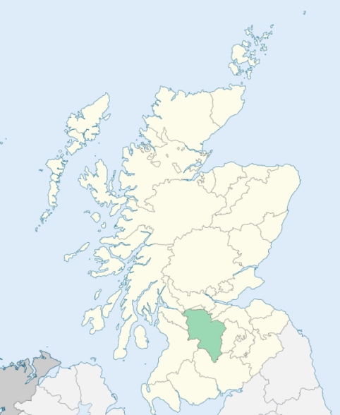

Photo credits: (Featured) Cadder Parish Church, © 2018 Tim Heaton, used under Creative Commons License CC BY-SA 2.0, (Related Resources) Lanarkshire Locator Map, © 2024, Elianfoo, used under Creative Commons License CC BY-SA 4.0.
Related Resources
Map of Scotland with Lanarkshire highlighted
Location of Lanarkshire
See more maps at Wikimedia Commons
Glossary
  • Burghs:
  • Royal - Towns on royal lands
  • Regality - Towns granted to noblemen/landowners
  • Barony - Towns granted to tenant-in-chief (laird)
  • Police - Towns with elected officials
  • Small - Population under 20,000
  • Large - Population over 20,000
  •  
  • Chapel-of-Ease: Small church for those living far from the main church
  • Collegiate church: See What is a Collegiate Church?
  • Commune kirk: Owned by a larger church
  • Court of Teinds: Controlled funds for support of clergy
  •  
  • Friars:
  • Black - Dominican
  • Grey - Franciscan
  • Red - Trinitarian
  • White - Carmelite
  •  
  • Iron chapel: Building made of corrugated galvanized iron
  •  
  • Landward District: Rural part of a district
  •  
  • Mensal: Source of income to support clergy member (Roman Catholic)
  •  
  • OPR: Old Parochial Register
  •  
  • Pre-Reformation: Before 1560
  • Prebend: Source of income to support a clergy member
  •  
  • QO: Quoad Omnia - Civil and church control
  • QS: Quoad Sacra - Church control only
  •  
  • RD: Registration District - Civil control
  •  
  • Tryst: Large-scale market or fair, particularly for livestock
  •