Logie Kenny
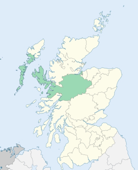
Laggan is a highland parish, comprising the south-west of the district of Badenoch, in Inverness-shire. It is bounded on the south by Perthshire, and on other sides by the parishes of Kilmonivaig, Boleskine, and Kingussie. (1867: The Imperial Gazetteer of Scotland, by John Marius Wilson).
Aberarder, Balgowan, Blargie, Catlodge, Kinloch Laggan, Laggan or Laggan Bridge, Melgarve, Moy
The parish of Kingussie & Inch had a detached part containing 2,133 acres, and surrounded by the parish of Laggan. This detached part has been transferred to the parish of Laggan. See affected properties and landholders. (1892: Boundary of counties and parishes in Scotland as settled by the Boundary Commissioners under the Local Government Act, 1889, by Hay Shennan)
PRE-REFORMATION GOVERNANCE:
POST-REFORMATION GOVERNANCE:
Laggan was in the Presbytery of Abertarff and Synod of Glenelg from 8 July 1724 to 25 Nov 1890, and was one of the original parishes which constituted that Presbytery. There are mission stations at Dalwhinnie and Loch Laggan.
Includes ministers, licentiates, assistants, readers, and clerks.
(1928: Fasti Ecclesiæ Scoticanæ, by Hew Scott, D. D.)
Parish registers turned over to the Registrar-General, as a result of the Registration of Births, Deaths, and Marriages (Scotland) Act of 1854. The letters B. D. and M. indicate Births (or Baptisms), Deaths (or Burials), and Marriages (or Proclamations of Banns) respectively. Numbers indicate separate volumes or books. Note: These records are by no means complete or without damage; consult the Detailed List of the Old Parochial Registers of Scotland (1872) to learn more about the condition of the records.
| OPR and RD Numbers | |||
|---|---|---|---|
| Date Range | Name | Number | Type |
| 1775-1854 | Laggan | 104 | OPR |
| 1855-1947 | Laggan | 104 | RD |
| 1948-1970 | Kingussie and Laggan | 102 | RD |
| 1971-1971 | Mallaig | 104 | RD |
| 2009 | (Laggan) Highland, Kingussie | 234 | RD |
| 2009 | (Mallaig) Highland, Mallaig and Knoydart | 239 | RD |
| 2026 | (Laggan) Highland Council; Laggan Community Council | ||
| 2026 | (Kingussie) Highland Council; Kingussie and Vicinity Community Council | ||
| 2026 | (Mallaig) Highland Council, Mallaig Community Council | ||
(2009: Parishes and Registration Districts of Scotland - Old and New, National Records of Scotland)
Local community councils (2026) are provided as a potential source of additional information for settlements within the original boundaries of the parish. (Source)
Statistics from informal and official censuses
Anderson, Cameron, Campbell, Fraser, Grant, Kennedy, MacDonald, MacPherson, Robertson, Smith
Note: Names appearing in research materials, other than censuses. Simple names (First name, surname only) have been omitted unless they appear associated with large properties. All women's names, and men's names with occupations, military ranks, or peerage titles are included.
By the Reverend Mr James Grant.
"Our business is managed and carried on by house-servants. There are a few who may have one, sometimes two, of their servants without the family; but this never happens unless the servant is a married man, with a family. He receives from his master a hut to live in; grass for a cow; ground to sow a boll or two of corn; and a small spot for planting 3 or 4 pecks of potatoes; with two pecks of meal a week. Sometimes, if he is better than the ordinary run of servants, he will, in addition to the above, receive £1 Sterling in the year.
There is one mason with two apprentices, in the parish; five or six weavers; no shoemakers regularly bred. The common people make their own shoes. There are three or four brogue-makers, three house-carpenters, seven tailors, and one blacksmith. Many of the inhabitants have emigrated into America; and many more are preparing to go to Australia."
(This section contains excerpts, at times restructured or paraphrased, from an article appearing in Statistical Account of Scotland, Sir John Sinclair, 1791-1799)
Primary Sources:
Statistical Account of Scotland (1791-1799), Volume 3, p. 145
New Statistical Account of Scotland (1834-1845), Volume 14, Section I, p. 417
See Parish Page Sources for all source information and links.