
Plaidwerx


Features: Scottish Parishes » Historic Shires » Roxburghshire » Maxton

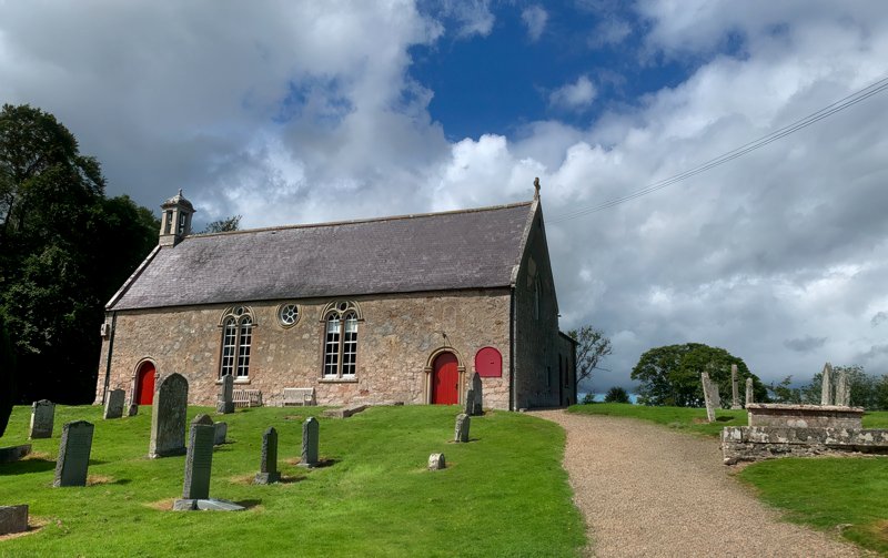
Maxton Kirk by John Mason
Maxton Kirk, Scottish Borders © 2020, John Mason

MAXTON PARISH

TABLE OF CONTENTS


ALTERNATE NAMES AND SPELLING:

  • Maccuston, Mackiston (Maxton)
  • Maxton and Rutherford

LOCATION

Location Description:

Maxton is a parish on the north border of Roxburghshire. It is bounded by Berwickshire, and by Makerston, Roxburgh, Ancrum, and St Boswells. (1867: The Imperial Gazetteer of Scotland, by John Marius Wilson).

Shire, District, and Region Timeline:

  • Shire: Roxburghshire (Before 1707)
  • County: Roxburgh (After 1707)
  • District: Castletown and Melrose (Before 1930)
  • Landward District: Melrose (1930-1975)
  • Region: Borders (1975-1996)
  • District: Ettrick and Lauderdale (1975-1996)

Cities, Towns, Villages, and Hamlets:

Maxton, Rutherford

Estates:

Rutherford


PARISH TIMELINE

PRE-REFORMATION GOVERNANCE:

  • Diocese: Glasgow
  • Deanery: Teviotdale

POST-REFORMATION GOVERNANCE:

  • Synod: Merse and Teviotdale
  • Presbytery: Selkirk, previously Melrose

PAROCHIAL OVERVIEW:

Maxton. The church of Maxton was dedicated to St Cuthbert. It belonged to the Abbey of Dryburgh.
Rutherford. There was here a hospital of St Magdalene.

CHURCH OF SCOTLAND CLERGY:

Includes ministers, licentiates, assistants, readers, and clerks.

  • Sir William Ainslie, 1561
  • John Smyth, 1593
  • Patrick Lindsay, 1634
  • Andrew Duncanson, 1640
  • Patrick Strachan, 1683
  • Robert Edgar, 1690
  • Gabriel Wilson, 1709
  • William Brown, 1751
  • David Clerk, 1770
  • Stephen Oliver, 1776
  • John Haining, 1805
  • John Thomson, 1810
  • Manners Hamilton Nisbet Graham, 1865
  • David Denholm M'Kerron, 1905

(1928: Fasti Ecclesiæ Scoticanæ, by Hew Scott, D. D.)


RECORDS

Parochial Registers:

Parish registers turned over to the Registrar-General, as a result of the Registration of Births, Deaths, and Marriages (Scotland) Act of 1854. The letters B. D. and M. indicate Births (or Baptisms), Deaths (or Burials), and Marriages (or Proclamations of Banns) respectively. Numbers indicate separate volumes or books. Note: These records are by no means complete or without damage; consult the Detailed List of the Old Parochial Registers of Scotland (1872) to learn more about the condition of the records.

  • (1) B. 1689-1820; M. 1691-1820; D. 1696-1803
  • (2) B. 1820-54; M. 1820-48; D. 1837-54

OPR and RD Numbers
Date RangeNameNumberType
1689-1854Maxton798OPR
1855-1967Maxton798RD
2009Scottish Borders, Melrose820RD
2026Scottish Borders Council; Maxton and Mertoun Community Council

(2009: Parishes and Registration Districts of Scotland - Old and New, National Records of Scotland)

Local community councils (2026) are provided as a potential source of additional information for settlements within the original boundaries of the parish. (Source)

Population:

Statistics from informal and official censuses

  • 1755: 397
  • 1782: 326
  • 1831: 462
  • 1841: 459
  • 1861: 497
  • 1901: 411
  • 1911: 380

RESIDENTS


Common Surnames:

Bell, Fairbairn, Lauder, Mitchell, Ormiston, Paterson, Simpson, Waddel, White, Whitson

Land-owners, teachers, and other professionals:

Note: Names appearing in research materials, other than censuses. Simple names (First name, surname only) have been omitted unless they appear associated with large properties. All women's names, and men's names with occupations, military ranks, or peerage titles are included.

  • Thomas Williamson RAMSAY, Esq., of Maxton
  • Hugh SCOTT, Esq., of Harden
  • Adam WALKER, Esq., of Muirhouselaw

Other residents:

By the Reverend Mr Stephen Oliver.
"About the year 1782, there was a pretty exact account taken of all the inhabitants of the parish. The number of persons above 10 years of age, amounted to 262, and of children below 10 years, to 64; in all 326. In Dr Webster's report (1755), the number is 397."
(This section contains excerpts, at times restructured or paraphrased, from an article appearing in Statistical Account of Scotland, Sir John Sinclair, 1791-1799)


NOTES:

Primary Sources:
Statistical Account of Scotland (1791-1799), Volume 3, p. 276
New Statistical Account of Scotland (1834-1845), Volume 3, Section I, p. 115

See Parish Page Sources for all source information and links.
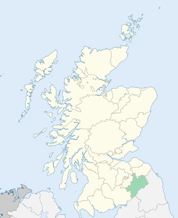

Photo credits: (Featured) Maxton Kirk, © 2020 John Mason, used under Creative Commons License CC BY 2.0, (Related Resources) Roxburghshire Locator Map, © 2024, Elianfoo, used under Creative Commons License CC BY-SA 4.0.
Related Resources
Map of Scotland with Roxburghshire highlighted
Location of Roxburghshire
See more maps at Wikimedia Commons
Glossary
  • Burghs:
  • Royal - Towns on royal lands
  • Regality - Towns granted to noblemen/landowners
  • Barony - Towns granted to tenant-in-chief (laird)
  • Police - Towns with elected officials
  • Small - Population under 20,000
  • Large - Population over 20,000
  •  
  • Chapel-of-Ease: Small church for those living far from the main church
  • Collegiate church: See What is a Collegiate Church?
  • Commune kirk: Owned by a larger church
  • Court of Teinds: Controlled funds for support of clergy
  •  
  • Friars:
  • Black - Dominican
  • Grey - Franciscan
  • Red - Trinitarian
  • White - Carmelite
  •  
  • Iron chapel: Building made of corrugated galvanized iron
  •  
  • Landward District: Rural part of a district
  •  
  • Mensal: Source of income to support clergy member (Roman Catholic)
  •  
  • OPR: Old Parochial Register
  •  
  • Pre-Reformation: Before 1560
  • Prebend: Source of income to support a clergy member
  •  
  • QO: Quoad Omnia - Civil and church control
  • QS: Quoad Sacra - Church control only
  •  
  • RD: Registration District - Civil control
  •  
  • Tryst: Large-scale market or fair, particularly for livestock
  •