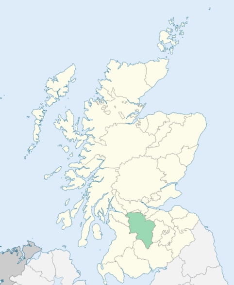
Blantyre is a parish in the north-west of Lanarkshire. It is bounded by the parishes of Kilbride, Cambuslang, Bothwell, Hamilton, and Glassford. (1867: The Imperial Gazetteer of Scotland, by John Marius Wilson).
Auchinraith, Auchintibber, Barnhill, Blantyre, Hunthill, Kirkton, Stonefield
Calderbank, Craighead
PRE-REFORMATION GOVERNANCE:
POST-REFORMATION GOVERNANCE:
In the fifteenth century the church of Blantyre was endowed as a collegiate church. It belonged to the Priory of Blantyre, within the parish. This Augustinian monastery was founded in 1295 and was a cell of Holyrood Abbey. Blantyre Church was rebuilt in 1793, and again in 1863.
Disjoined Quoad Sacra Parishes:
Stonefield. A church was built here in 1880. The parish of Stonefield was disjoined from Blantyre, 24 February 1890.
Includes ministers, licentiates, assistants, readers, and clerks.
Blantyre (QO)
Stonefield (QS)
(1928: Fasti Ecclesiæ Scoticanæ, by Hew Scott, D. D.)
Parish registers turned over to the Registrar-General, as a result of the Registration of Births, Deaths, and Marriages (Scotland) Act of 1854. The letters B. D. and M. indicate Births (or Baptisms), Deaths (or Burials), and Marriages (or Proclamations of Banns) respectively. Numbers indicate separate volumes or books. Note: These records are by no means complete or without damage; consult the Detailed List of the Old Parochial Registers of Scotland (1872) to learn more about the condition of the records.
| OPR and RD Numbers | |||
|---|---|---|---|
| Date Range | Name | Number | Type |
| 1677-1854 | Blantyre | 624 | OPR |
| 1855-1971 | Blantyre | 624 | RD |
| 1972-1992 | Blantyre | 574 | RD |
| 2009 | South Lanarkshire; Hamilton | 577 | RD |
| 2026 | South Lanarkshire Council; Blantyre Community Council | ||
(2009: Parishes and Registration Districts of Scotland - Old and New, National Records of Scotland)
Local community councils (2026) are provided as a potential source of additional information for settlements within the original boundaries of the parish. (Source)
Statistics from informal and official censuses
Brown, Kelly, Paterson, Robertson, Scott, Smith, Struthers, Thomson, Watson, Wilson
Note: Names appearing in research materials, other than censuses. Simple names (First name, surname only) have been omitted unless they appear associated with large properties. All women's names, and men's names with occupations, military ranks, or peerage titles are included.
By the Reverend Mr Henry Stevenson.
"In 1755 the population was 496. But in 1787, the number of inhabitants was immediately and greatly increased, by means of a cotton mill erected upon the Clyde. Before that period, the number of inhabitants above 8 years old, was about 400. The number of families, including every individual who possessed a separate lodging, was 130; the number of souls being about 520. Since the year 1787 when the cotton mill began to work, the population has been making continual and rapid progress; and, as the machinery is not nearly completed, they are still daily increasing.
The numbers at the cotton mill were not exactly ascertained, till the 14th March, 1791; and, at that date, they stood as follows: 295 men, women, and children, employed at the mill; 60 barracks children, also employed in the mill (these children are, in general, orphans, between 8 and 12 years of age); 13 piecers to the jeannies; 56 wives and widows employed at home in family affairs; 96 children, not of age to be employed; total 520. Thus, the number of inhabitants, in the parish, has been doubled, in the course of about 4 years, and may now amount to 1040 souls.
There are no manufactures established in the parish, except the cotton branch. The only tradesmen in the place, are such as find employment from the country people; except a few weavers, who are employed by manufacturers in Glasgow.
The inhabitants, in general, are remarkably industrious, sober, and contented: And from the smallness of the parish, as well as their peculiar circumstances of independence, they have acquired a strong spirit of equality, and a sort of esprit du corps, that renders them ready to unite in supporting their common privileges. No instance can be remembered, of any person belonging to the parish, suffering any capital punishment."
(This section contains excerpts, at times restructured or paraphrased, from an article appearing in Statistical Account of Scotland, Sir John Sinclair, 1791-1799)
Primary Sources:
Statistical Account of Scotland (1791-1799), Volume 2, p. 213
New Statistical Account of Scotland (1834-1845), Volume 6, p. 314
See Parish Page Sources for all source information and links.