Monyabroch
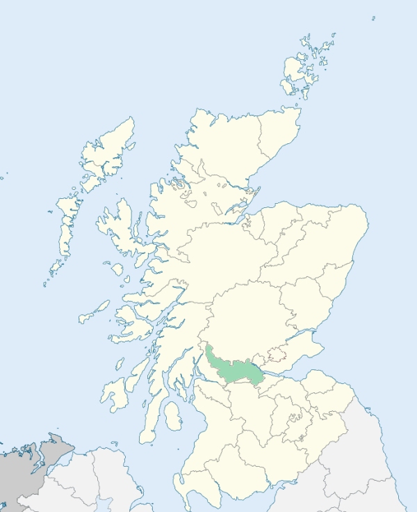
Kilsyth is a parish in Stirlingshire. It is bounded on the south by Dumbartonshire, and on other sides by the parishes of Campsie, Fintry, St Ninians, and Denny. (1867: The Imperial Gazetteer of Scotland, by John Marius Wilson).
Arnbrae, Auchincloch, Auchinmully or Lower Banton, Banton, Chapel Green, Craigmarloch, High Banton, Hollandbush, Inchterf, Kilsyth, Monaebrugh
Berryhill
PRE-REFORMATION GOVERNANCE:
POST-REFORMATION GOVERNANCE:
In 1649 the western part of the Barony of Kilsyth was disjoined from Campsie and added to the parish of Monyabroch, which was thenceforth called Kilsyth. Within the bounds there were wells of St Mirin and St Talorgan. Kilsyth Church was rebuilt on a new site in 1816.
Disjoined Quoad Sacra Parishes:
Banton. A church was built here in 1838, and on 28 May that year it was constituted a chapel with a district. On 6 December 1880 the parish of Banton was disjoined from Kilsyth.
Includes ministers, licentiates, assistants, readers, and clerks.
Kilsyth (QO)
Banton (QS)
(1928: Fasti Ecclesiæ Scoticanæ, by Hew Scott, D. D.)
Parish registers turned over to the Registrar-General, as a result of the Registration of Births, Deaths, and Marriages (Scotland) Act of 1854. The letters B. D. and M. indicate Births (or Baptisms), Deaths (or Burials), and Marriages (or Proclamations of Banns) respectively. Numbers indicate separate volumes or books. Note: These records are by no means complete or without damage; consult the Detailed List of the Old Parochial Registers of Scotland (1872) to learn more about the condition of the records.
| OPR and RD Numbers | |||
|---|---|---|---|
| Date Range | Name | Number | Type |
| 1619-1854 | Kilsyth | 483 | OPR |
| 1855-1971 | Kilsyth | 483 | RD |
| 1972-2006 | Kilsyth | 476 | RD |
| 2009 | North Lanarkshire, Kilsyth | 476 | RD |
| 2026 | North Lanarkshire Council; Kilsyth Community Council | ||
(2009: Parishes and Registration Districts of Scotland - Old and New, National Records of Scotland)
Local community councils (2026) are provided as a potential source of additional information for settlements within the original boundaries of the parish. (Source)
Statistics from informal and official censuses
Anderson, Brown, Burns, Cleland, Marshall, Miller, Patrick, Shaw, Wilson, Young
Note: Names appearing in research materials, other than censuses. Simple names (First name, surname only) have been omitted unless they appear associated with large properties. All women's names, and men's names with occupations, military ranks, or peerage titles are included.
By the Reverend Mr Robert Rennie.
"The population of this parish may be very accurately stated. For in the year 1790, an exact list was taken of every individual in it: at that time it contained precisely 2450 souls. There were 208 houses, 506 families, 902 heads of families, 1458 children, 118 farmers, 68 men-servants, and 99 maid-servants. There may be about a hundred families or householders that have no children.
There were 400 weavers, 280 tambourers, 15 tailors, 10 masons, 12 wrights, 2 coopers, 5 carters, 4 flax-dressers, 3 gardeners, 2 nailers, 10 smiths, 3 wheel-wrights, 5 butchers, 12 shoemakers, 5 millers, 1 toll-keeper, 6 sickle makers, 1 clock-maker, 12 publicans, 24 labourers, 23 grocers, 6 colliers, 40 miners, 1 excise officer, 3 sheriff officers, 7 stocking makers, 2 bakers, 2 surgeons, 4 seamstresses, 1 drummer, 2 carriers, and 5 teachers.
The characters of the inhabitants of this parish, are as various as their countenances; as in every mixed society, the good and bad are blended together. To speak in general terms, however, they are punctual in their attendance on religious ordinances, decent and devout in their external appearance, and regular in their manners. They are sober, active, and industrious; open, candid, and even generous in their dealings; loyal to their sovereign, obedient to all lawful authorities; and they study to leave peaceable and quiet lives, in all godliness and honesty.
Upwards of one half of the inhabitants can trace back their parentage, for many generations, all natives of this parish. Independent in their circumstances, and of a more independent spirit, they have a high sense of honour, and a great regard to character. The above will by many be deemed a flattering picture; and I dare say, I may be accused of partiality. My only plea is, that I have been born and bred among them; upwards of 500 of them are my blood relations."
(This section contains excerpts, at times restructured or paraphrased, from an article appearing in Statistical Account of Scotland, Sir John Sinclair, 1791-1799)
Primary Sources:
Statistical Account of Scotland (1791-1799), Volume 18, p. 214
New Statistical Account of Scotland (1834-1845), Volume 8, Section II, p. 138
See Parish Page Sources for all source information and links.