Barraigh, Barray, Kilbarr
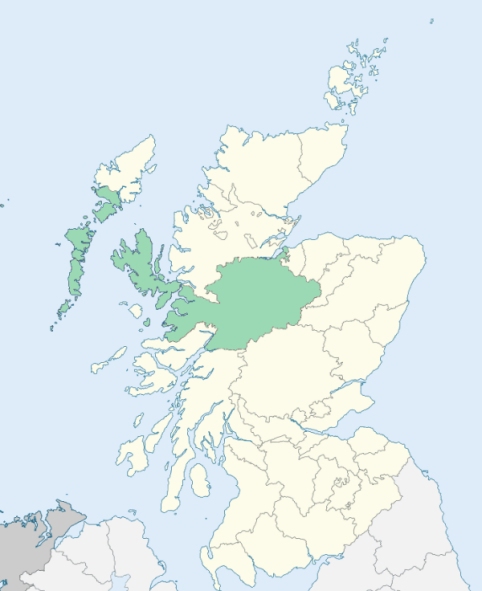
Barra is an island parish at the southern extremity of the Outer Hebrides, Inverness-shire. It comprises a group of nine inhabited islands and upwards of a dozen uninhabited ones. The nearest land to it on the north is South Uist, on the east Canna and Rum, on the south, Tiree, and on the west, North America. The inhabited islands are Barra, Watersa, Sandera, Pabba, Mingala, Bernera, Helesa, Fladda, and Fuda. The island of Barra contains five-sixths of the whole population, and is also the main island in point of size. All these islands are difficult of access, on account of the strong currents running between them. (1867: The Imperial Gazetteer of Scotland, by John Marius Wilson).
Allasdale, Ardmore, Ardveenish, Balnabodach, Brevig, Bruernish, Caolas, Castle or Kismull, Castlebay, Cleat, Cuier, Earsary, Eoligarry, Garrygal, Greian, Kentangaval, Leanish, Nask, Northbay, Saltinish, Tangusdale, Uidh
PRE-REFORMATION GOVERNANCE:
POST-REFORMATION GOVERNANCE:
Barra was annexed to South Uist, Kilpheatair, and Benbecula in the latter half of the seventeenth century, the reason being that there were hardly any Protestants in it to minister to, and the great body of the parishioners still adhere to the Roman Catholic Church. The parish was disjoined from South Uist and erected by the Commissioners of Teinds 14 February 1733. The church was dedicated to St Barr. On the island of Barra there were chapels of St Breandan at Borve and St Mary at Kilmorie.
Includes ministers, licentiates, assistants, readers, and clerks.
(1928: Fasti Ecclesiæ Scoticanæ, by Hew Scott, D. D.)
Parish registers turned over to the Registrar-General, as a result of the Registration of Births, Deaths, and Marriages (Scotland) Act of 1854. The letters B. D. and M. indicate Births (or Baptisms), Deaths (or Burials), and Marriages (or Proclamations of Banns) respectively. Numbers indicate separate volumes or books. Note: These records are by no means complete or without damage; consult the Detailed List of the Old Parochial Registers of Scotland (1872) to learn more about the condition of the records.
| OPR and RD Numbers | |||
|---|---|---|---|
| Date Range | Name | Number | Type |
| 1836-1854 | Barra | 108 | OPR |
| 1855-1971 | Barra | 108 | RD |
| 1972-2006 | Barra | 254 | RD |
| 2009 | Comhairle Nan Eilean Siar | 254 | RD |
| 2026 | Na h-Eileanan Siar Council; Castlebay and Vatersay Community Council Northbay Community Council | ||
(2009: Parishes and Registration Districts of Scotland - Old and New, National Records of Scotland)
Local community councils (2026) are provided as a potential source of additional information for settlements within the original boundaries of the parish. (Source)
Statistics from informal and official censuses
Boyd, Buchanan, Cameron, Campbell, Galbraith, MacDonald, MacIntyre, MacLean, MacNeil, Nicholson
Note: Names appearing in research materials, other than censuses. Simple names (First name, surname only) have been omitted unless they appear associated with large properties. All women's names, and men's names with occupations, military ranks, or peerage titles are included.
By the Reverend Mr Edward MacQueen.
"At present, the number of souls in this parish is 760 males, and 864 females, in all 1604, of which only 80 are Protestants. Besides this number, upwards of 200 left this country within the last 2 years; some emigrated to the island of St John's and Nova Scotia, in North America, being inveigled thither by a Mr F*** upon promises of the undisturbed profession of their religion (being all Roman Catholics), and of free property for themselves, and their offspring forever; but how soon they were landed, he left them to their shifts and returned back to his native country.
The Gaelic is the only language commonly spoken here, and I believe the purest dialect of it to be met with in any country; though by their frequent excursions to Glasgow, the people have introduced a number of English words."
(This section contains excerpts, at times restructured or paraphrased, from an article appearing in Statistical Account of Scotland, Sir John Sinclair, 1791-1799)
Primary Sources:
Statistical Account of Scotland (1791-1799), Volume 13, p. 326
New Statistical Account of Scotland (1834-1845), Volume 14, Section I, p. 36
See Parish Page Sources for all source information and links.