Inverkeithing and Rosyth
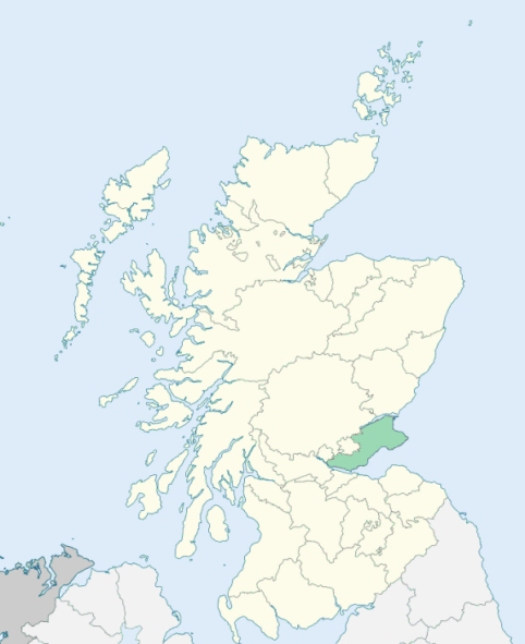
Inverkeithing is a parish on the south coast of the western part of Fife. It is bounded by the Firth of Forth, and by the parishes of Dunfermline and Dalgety. The island of Inchgarvie and the Rock of Bimar (Beamer Rock) belong to it. (1867: The Imperial Gazetteer of Scotland, by John Marius Wilson).
Hillend, Inverkeithing, Jamestown, Limekilns
Whereas a part of the parish of Dunfermline, forming a portion of the estate of Moreland, is situated or alleged to be situated in the county of Kinross, the rest of the said parish being situated in the county of Fife:
And whereas a part of the parish of Dunfermline, situated at or near North Queensferry and lying to the south of the parish of Inverkeithing, is detached from the main portion of the parish of Dunfermline:
And whereas a part of the parish of Inverkeithing, situated at or near Milesmark and almost surrounded by the parish of Dunfermline, is detached from the main portion of the said parish of Inverkeithing:
I. So much of the parish of Dunfermline as lies to the north of the south march of the estate of Moreland shall form part of the parish of Cleish and of the county of Kinross.
II. The aforesaid detached part of the parish of Dunfermline shall cease to be part of that parish, and shall form part of the parish of Inverkeithing.
III. The aforesaid detached part of the parish of Inverkeithing, and so much of the parish of Inverkeithing as lies to the west of the east march of the farm of Brucehaven (otherwise called Claysikes), shall cease to be part of the parish of Inverkeithing, and shall form part of the parish of Dunfermline.
See affected properties and landholders. (1892: Boundary of counties and parishes in Scotland as settled by the Boundary Commissioners under the Local Government Act, 1889, by Hay Shennan)
PRE-REFORMATION GOVERNANCE:
POST-REFORMATION GOVERNANCE:
The parishes of Inverkeithing and Rosyth were united in 1618.
Inverkeithing. Inverkeithing church, dedicated to St Peter, was granted to Dunfermline Abbey by Waldeve, son of Gospatrick, 1160-82. In 1825 the church of Inverkeithing was burned. A friary of the Grefriars was founded at Inverkeithing, 1329-84. The chapel of Inverkeithing was conveyed to Dunfermline Abbey by Malcolm IV in 1159.
Rosyth. The church of Rosyth, traditionally said to have been dedicated to St John, and granted to the monastery of Inchcolm by Richard, Bishop of Dunkeld in 1170-89, ceased to be used as a place of worship soon after 1630, and is now a ruin.
Disjoined Quoad Sacra Parishes:
Mossgreen. A church was built in 1852 and enlarged in 1877. Mossgreen became a chapel-of-ease in 1860. The parish was disjoined from Aberdour, Dalgety, Inverkeithing, and Dunfermline, 13 January 1879.
(1928: Fasti Ecclesiæ Scoticanæ, by Hew Scott, D. D.)
Includes ministers, licentiates, assistants, readers, and clerks.
Inverkeithing (QO)
Mossgreen (QS)
(1928: Fasti Ecclesiæ Scoticanæ, by Hew Scott, D. D.)
Parish registers turned over to the Registrar-General, as a result of the Registration of Births, Deaths, and Marriages (Scotland) Act of 1854. The letters B. D. and M. indicate Births (or Baptisms), Deaths (or Burials), and Marriages (or Proclamations of Banns) respectively. Numbers indicate separate volumes or books. Note: These records are by no means complete or without damage; consult the Detailed List of the Old Parochial Registers of Scotland (1872) to learn more about the condition of the records.
| OPR and RD Numbers | |||
|---|---|---|---|
| Date Range | Name | Number | Type |
| 1676-1854 | Inverkeithing | 432 | OPR |
| 1855-1855 | Inverkeithing Burgh | 432-1 | RD |
| 1855-1855 | Inverkeithing Landward | 432-2 | RD |
| 1856-1971 | Inverkeithing | 432 | RD |
| 1972-2007 | Inverkeithing | 436 | RD |
| 2009 | Fife, Inverkeithing | 436 | RD |
| 2026 | Fife Council; Inverkeithing Community Council | ||
(2009: Parishes and Registration Districts of Scotland - Old and New, National Records of Scotland)
Local community councils (2026) are provided as a potential source of additional information for settlements within the original boundaries of the parish. (Source)
Statistics from informal and official censuses
Adamson, Beveridge, Brown, Gibson, Hamilton, Henderson, Hutton, Robertson, Thomson, Wilson
Note: Names appearing in research materials, other than censuses. Simple names (First name, surname only) have been omitted unless they appear associated with large properties. All women's names, and men's names with occupations, military ranks, or peerage titles are included.
By the Reverend Mr Andrew Robertson, Minister.
"The population, by an accurate survey in the beginning of the present year, 1793, amount to 2210 souls. There are 1330 in the town, 312 in the North Ferry, and 568 in the country parish. The number of males was 1056; the number of females 1154. The population has greatly increased within these few years, owing to the flourishing state of the coal trade brought from Halbeath and shipped here, to a considerable distillery and brewery in the neighbourhood of the town, and a branch of the iron foundry business lately introduced.
The people in general are sober, industrious, and attentive; they follow their several employments with assiduity and care, and earn a comfortable livelihood for themselves and family. They seem to be contented and happy with their situation in life. Upon the whole, the people, with a few exceptions, are religious and devout, peaceable and useful members of society, and attached to their king and country, its civil constitution, and its mild, equitable, and salutary laws."
(This section contains excerpts, at times restructured or paraphrased, from an article appearing in Statistical Account of Scotland, Sir John Sinclair, 1791-1799)
Primary Sources:
Statistical Account of Scotland (1791-1799), Volume 10, p. 551
New Statistical Account of Scotland (1834-1845), Volume 9, Section I, p. 230
See Parish Page Sources for all source information and links.