Earltown, Ercildoune, Ersildun
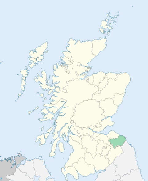
Earlston is a parish in the south of Lauderdale, Berwickshire. It is bounded on the north by Legerwood and Gordon, on the east by Hume, and Nenthorn, on the south by Roxburghshire and Merton, and on the west by Leader Water, which divides it from Roxburghshire. (1867: The Imperial Gazetteer of Scotland, by John Marius Wilson).
Earlston, Fans, Netherstain, Redpath
Cowdenknowes, Mellerstain
The parish of Earlston had a small detached part which was also a detached part of the county of Berwick, and was surrounded by the county of Roxburgh. Within the county of Berwick the parish of Lauder had a detached part situated on the west of the Leader Water and projecting into the parish of Melrose and the county of Roxburgh. Two changes were made on the county boundary:
(a) the detached part of the parish of Lauder was transferred to the parish of Melrose, and at the same time to the county of Roxburgh;
(b) so much of Earlston parish as lay to the west of the Leader Water (including the detached part) was transferred to the parish of Melrose and to the county of Roxburgh.
See affected properties and landholders. (1892: Boundary of counties and parishes in Scotland as settled by the Boundary Commissioners under the Local Government Act, 1889, by Hay Shennan)
PRE-REFORMATION GOVERNANCE:
POST-REFORMATION GOVERNANCE:
The church was originally a chapel under Edrom. Walter de Lindsay granted it to the monks of Kelso, who, in 1171, exchanged it with the Priory of Coldingham for the church of Gordon. It was dedicated by Bishop David de Bernham, 20 March 1242. A new church was opened 6 July 1892. A hospital existed here in very early times. In Earlston a yearly fair is held on St Peter's Day, 29 June.
Includes ministers, licentiates, assistants, readers, and clerks.
(1928: Fasti Ecclesiæ Scoticanæ, by Hew Scott, D. D.)
Parish registers turned over to the Registrar-General, as a result of the Registration of Births, Deaths, and Marriages (Scotland) Act of 1854. The letters B. D. and M. indicate Births (or Baptisms), Deaths (or Burials), and Marriages (or Proclamations of Banns) respectively. Numbers indicate separate volumes or books. Note: These records are by no means complete or without damage; consult the Detailed List of the Old Parochial Registers of Scotland (1872) to learn more about the condition of the records.
| OPR and RD Numbers | |||
|---|---|---|---|
| Date Range | Name | Number | Type |
| 1694-1854 | Earlston | 736 | OPR |
| 1855-1971 | Earlston | 736 | RD |
| 1972-1995 | Earlston | 792 | RD |
| 2009 | Scottish Borders, Melrose | 820 | RD |
| 2026 | Scottish Borders Council; Earlston Community Council | ||
(2009: Parishes and Registration Districts of Scotland - Old and New, National Records of Scotland)
Local community councils (2026) are provided as a potential source of additional information for settlements within the original boundaries of the parish. (Source)
Statistics from informal and official censuses
Aitchison, Douglas, Hogg, Kerr, Pringle, Robertson, Scott, Tait, Wallace, Wilson
Note: Names appearing in research materials, other than censuses. Simple names (First name, surname only) have been omitted unless they appear associated with large properties. All women's names, and men's names with occupations, military ranks, or peerage titles are included.
By the Reverend Mr Laurence Johnston.
"At the time of Dr Webster's report (1755), the numbers were 1197. There are at present (1791) 670 males, and 681 females. In all, 1351 souls. 653 are of the Established Church, the rest are Sectaries. The farms are now much larger than formerly. What used to serve 12 or 13 farmers, is now occupied by 4.
Although the parish consists chiefly of villages, yet very few manufactures are carried on in it. The principal one is linen cloth. There are between 40 and 50 weavers looms, mostly employed weaving linen, and the greatest part of that cloth is for sale. We have only one woollen manufacturer. There are 4 mills in the parish, which manufacture a considerable quantity of all kinds of grain. There are about 2000 sheep in the parish; the farmers also rear a considerable number of black cattle every year."
(This section contains excerpts, at times restructured or paraphrased, from an article appearing in Statistical Account of Scotland, Sir John Sinclair, 1791-1799)
Primary Sources:
Statistical Account of Scotland (1791-1799), Volume 4, p. 248
New Statistical Account of Scotland (1834-1845), Volume 2, Section III, p. 18
See Parish Page Sources for all source information and links.