Kilbride in Arran
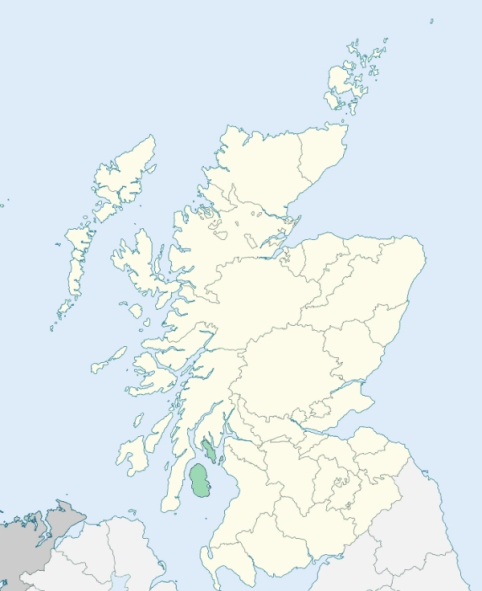
Kilbride is a parish comprising the east side of the island of Arran, except about 2 miles at the south end of the island, in Buteshire. (1867: The Imperial Gazetteer of Scotland, by John Marius Wilson).
Broadick or Brodick, Corrie, Lamlash, Ledaig, Sannox
Kilmichael
PRE-REFORMATION GOVERNANCE:
POST-REFORMATION GOVERNANCE:
The church of Kilbride belonged to the Abbey of Kilwinning. It was dedicated to St Bride. In the year 1600 this parish was included in the Presbytery of Irvine. But in 1638, when the Presbytery of Kintyre was formed, Kilbride and Kilmorie in Arran were both enrolled in the new Court.
Disjoined Quoad Sacra Parishes:
Brodick. The parish of Brodick was disjoined from Kilbride in Arran, 15 July 1863. Within its bounds are the sites of two ancient chapels of St Michael, the one at Kilmichael in Glencloy, and the other at Kilmichael in Sannox. There is a mission chapel in the parish at Corrie.
Connel. This parish gets its name from an ancient chapel of St Conal which stood at the landing-place where Conal Ferry crosses Loch Etive. On 18 March 1910, the parish of Connel was disjoined from St Columba's, Oban, Muckairn, and Kilbride. The modern parish church is styled St Oran's.
Whiting Bay. A church was built for this part of Arran in 1873. On 19 March 1908 the parish of Whiting Bay was disjoined from Kilbride and Kilmorie. On the Holy Island, overlooking the shore opposite Lamlash, within the parish, are the cave and chapel of St Malise. There, for a time, the saint is said to have dwelt. In later times the place was occupied as a hermitage in his honour.
Includes ministers, licentiates, assistants, readers, and clerks.
Kilbride (QO)
Brodick (QS)
Connel (QS)
Whiting Bay (QS)
(1928: Fasti Ecclesiæ Scoticanæ, by Hew Scott, D. D.)
Parish registers turned over to the Registrar-General, as a result of the Registration of Births, Deaths, and Marriages (Scotland) Act of 1854. The letters B. D. and M. indicate Births (or Baptisms), Deaths (or Burials), and Marriages (or Proclamations of Banns) respectively. Numbers indicate separate volumes or books. Note: These records are by no means complete or without damage; consult the Detailed List of the Old Parochial Registers of Scotland (1872) to learn more about the condition of the records.
| OPR and RD Numbers | |||
|---|---|---|---|
| Date Range | Name | Number | Type |
| 1723-1854 | Kilbride | 553 | OPR |
| 1855-1865 | Kilbride | 553 | RD |
| 1866-1967 | Kilbride | 553-2 | RD |
| 1866-1967 | Brodick | 553-1 | RD |
| 1968-1971 | Brodick | 553 | RD |
| 1972-1997 | Lamlash | 553 | RD |
| 1998-2004 | Isle of Arran, Bute | 553 | RD |
| 2005-2008 | Isle of Arran, North Ayrshire | 553 | RD |
| 2009 | North Ayrshire, Isle of Arran | 553 | RD |
| 2026 | North Ayrshire Council; Arran Community Council | ||
(2009: Parishes and Registration Districts of Scotland - Old and New, National Records of Scotland)
Local community councils (2026) are provided as a potential source of additional information for settlements within the original boundaries of the parish. (Source)
Statistics from informal and official censuses
Cook, Crawford, Currie, Hamilton, Kelso, Kerr, Nicol, Robertson, Stewart, Watson
Note: Names appearing in research materials, other than censuses. Simple names (First name, surname only) have been omitted unless they appear associated with large properties. All women's names, and men's names with occupations, military ranks, or peerage titles are included.
By the Reverend Mr Gershom Stuart, Minister.
"The number of souls, at present (1793) in the parish is 2545. The return in 1755 was 1369. This increase would have been considerably greater, had not the population diminished of late; as upwards of 300 sailors go annually to the royal navy, the bounty fishing, or on board merchant ships, many of whom never return.
The whole inhabitants belong to the Established Church, and are a sober well disposed people. They attend divine service with great regularity; are well acquainted with the Scriptures; shew a good example to their children, and instruct them in the principles of Christianity."
(This section contains excerpts, at times restructured or paraphrased, from an article appearing in Statistical Account of Scotland, Sir John Sinclair, 1791-1799)
Primary Sources:
Statistical Account of Scotland (1791-1799), Volume 8, p. 578
New Statistical Account of Scotland (1834-1845), Volume 5, Section II, p. 1
See Parish Page Sources for all source information and links.