Kirkoswald of Turnberry
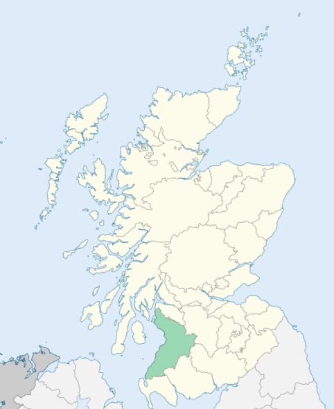
Kirkoswald is a parish on the coast of Carrick, in Ayrshire. It is bounded on the west by the Firth of Clyde, and on other sides by the parishes of Maybole, Kirkmichael, Dailly, and Girvan. (1867: The Imperial Gazetteer of Scotland, by John Marius Wilson).
Crosshill, Kirkoswald, Maidens
PRE-REFORMATION GOVERNANCE:
POST-REFORMATION GOVERNANCE:
The parish church was dedicated to St Oswald. It belonged to the Abbey of Crossregal (Crossraguel) within the parish. This Cluniac Monastery, dedicated to St Mary, was founded in 1244 by Duncan, Earl of Carrick. In early documents this place is often called Kirkoswald of Turnberry, in contrast to the village and Chapel of Kirkoswald in the parish of Ballantrae. The ancient church of this parish stands roofless in the churchyard. Its successor is in the village of Kirkoswald.
Disjoined Quoad Sacra Parishes:
Crosshill. A church was built here in 1838. The parish of Crosshill was disjoined from Kirkmichael and Kirkoswald, 8 March 1854.
Maybole West. A church was built here about 1840 by Sir Charles Dalrymple Fergusson of Kilkerran, Bart. The parish was disjoined from Maybole and Kirkoswald, 2 July 1862.
Includes ministers, licentiates, assistants, readers, and clerks.
Kirkoswald (QO)
Crosshill (QS)
Maybole West (QS)
(1928: Fasti Ecclesiæ Scoticanæ, by Hew Scott, D. D.)
Parish registers turned over to the Registrar-General, as a result of the Registration of Births, Deaths, and Marriages (Scotland) Act of 1854. The letters B. D. and M. indicate Births (or Baptisms), Deaths (or Burials), and Marriages (or Proclamations of Banns) respectively. Numbers indicate separate volumes or books. Note: These records are by no means complete or without damage; consult the Detailed List of the Old Parochial Registers of Scotland (1872) to learn more about the condition of the records.
| OPR and RD Numbers | |||
|---|---|---|---|
| Date Range | Name | Number | Type |
| 1694-1854 | Kirkoswald | 601 | OPR |
| 1855-1968 | Kirkoswald | 601 | RD |
| 2009 | South Ayrshire, Maybole | 683 | RD |
| 2026 | South Ayrshire Council; Kirkoswald, Maidens and Turnberry Community Council | ||
(2009: Parishes and Registration Districts of Scotland - Old and New, National Records of Scotland)
Local community councils (2026) are provided as a potential source of additional information for settlements within the original boundaries of the parish. (Source)
Statistics from informal and official censuses
Campbell, Crawford, Davidson, Girvan, Harvey, Irvine, Jamieson, Murray, Rodger, Smith
Note: Names appearing in research materials, other than censuses. Simple names (First name, surname only) have been omitted unless they appear associated with large properties. All women's names, and men's names with occupations, military ranks, or peerage titles are included.
By the Reverend Mr Matthew Biggar, Minister of the Parish.
"In the year 1791, the inhabitants were numbered; the result of this enumeration may be specified as follows: 643 males, 692 females, 1335 total number of souls, of whom 358 were below the age of 10. There are 280 inhabited houses in the parish. There were never any seceders in this parish till the year 1790, when one family came from Beith, of the Burgher persuasion.
The bulk of the inhabitants are farmers, who possess at an average about 130 acres of ground. The number of tenants is 76; of subtenants 26. Servants of every description do not exceed 120. The females are rather more numerous than the males. About 20 of both sexes are employed in domestic services; the rest in managing the dairy and farm. Cottagers are in number 109, and rent from the farmer a house and yard, and an acre or two of land.
At the end of July 1792, the division and occupations of the inhabitants of this parish might be stated as follows: 16 weavers, 2 gardeners with 6 journeymen, 6 blacksmiths, 5 cart-wrights, 1 ship-carpenter, 5 joiners, 6 shoemakers, 4 millers, 4 tailors, 1 grocer, 18 fishermen and seamen, and 4 miners. Among the above number are seven licensed retailers of ale and British spirits. There is one licensed retailer of wine and foreign spirits, who resides in the village.
In no one part of the parish, except the village of Kirkoswald, is there any number of houses together. In the village there are only 17 families. In these circumstances it cannot be expected, that manufactures can be any way very prevalent. There is one species of manufacture in this parish, which ought not to be omitted; that is, the manufacturing of wool into coarse blanketing and plaiding. This is chiefly carried on by the farmers, who have a number of daughters or female servants, and by the cottagers and their families."
(This section contains excerpts, at times restructured or paraphrased, from an article appearing in Statistical Account of Scotland, Sir John Sinclair, 1791-1799)
Primary Sources:
Statistical Account of Scotland (1791-1799), Volume 10, p. 474
New Statistical Account of Scotland (1834-1845), Volume 5, Section I, p. 781
See Parish Page Sources for all source information and links.