Kerry, or Kerriff, and Otter
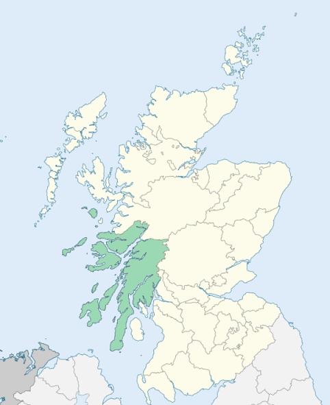
Kilfinan is a parish in Cowal, Argyleshire. It is bounded by Stralachan, Kilmodan, Loch Riddon, the West Kyles of Bute, and Loch Fyne. The southern division is called Kerriff or Kerry, which is from a Gaelic word which signfies a quarter or fourth-part of Anything. As it is by far the most extensive division, and the parish church is within it, the whole parish often goes by the name Kerry. The northern division is called Otter, which is also a Gaelic word, descriptive of a shallow place of which runs a gentle current. (1867: The Imperial Gazetteer of Scotland, by John Marius Wilson).
Kames, Kilfinan, Millhouse, Tighnabruaich
Ardmarnock, Ballimore
PRE-REFORMATION GOVERNANCE:
POST-REFORMATION GOVERNANCE:
The church of Kilfinan belonged to the Abbey of Paisley. A yearly fair in honour of its patron, St Finan, was held in the parish. There was within the bounds a chapel of St Bride, at Kilbride, where there is now a mission chapel.
Disjoined Quoad Sacra Parishes:
Tighnabruaich. A chapel for the Poltalloch district was built in 1862. The parish of Tighnabruaich was disjoined from Kilfinan, 10 March 1882.
Includes ministers, licentiates, assistants, readers, and clerks.
Kilfinan (QO)
Tighnabruaich (QS)
(1928: Fasti Ecclesiæ Scoticanæ, by Hew Scott, D. D.)
Parish registers turned over to the Registrar-General, as a result of the Registration of Births, Deaths, and Marriages (Scotland) Act of 1854. The letters B. D. and M. indicate Births (or Baptisms), Deaths (or Burials), and Marriages (or Proclamations of Banns) respectively. Numbers indicate separate volumes or books. Note: These records are by no means complete or without damage; consult the Detailed List of the Old Parochial Registers of Scotland (1872) to learn more about the condition of the records.
| OPR and RD Numbers | |||
|---|---|---|---|
| Date Range | Name | Number | Type |
| 1728-1854 | Kilfinan | 518 | OPR |
| 1855-1969 | Kilfinan | 518 | RD |
| 2007-2011 | Argyll and Bute, South Cowal | 531 | RD |
| 2026 | Argyll and Bute Council; Kilfinan Community Council | ||
(2009: Parishes and Registration Districts of Scotland - Old and New, National Records of Scotland)
Local community councils (2026) are provided as a potential source of additional information for settlements within the original boundaries of the parish. (Source)
Statistics from informal and official censuses
Blair, Brown, Crawford, Douglas, Kerr, Lamont, Millar, Thomson, Turner, Whyte
Note: Names appearing in research materials, other than censuses. Simple names (First name, surname only) have been omitted unless they appear associated with large properties. All women's names, and men's names with occupations, military ranks, or peerage titles are included.
By the Reverend Mr Alexander M'Farlane .
"According to an exact survey taken in April 1793, the number of inhabitants was 1417 souls, of whom 342 were under 10 years of age. There were 310 families. Their professions were 98 farmers, 112 sailors and fishers, 7 wrights, 38 weavers, 22 tailors, 11 shoemakers, 11 innkeepers, 3 millers, 12 cowans, 212 cottagers, 3 smiths, 1 flax-dresser, 1 distiller, 1 dyer and waulk miller, and 1 kelper. The herring-fishing takes up a great part of the time, and employs almost all the young men, and many of the married men, in this parish, during the season of it; which commonly begins in July and ends about Christmas.
In the above account of tradesmen, it is proper to observe, that masters, journeymen, and apprentices, are all taken into the number, and perhaps some of them, who work at times at different trades, may be twice reckoned, especially among the fishers, as many of them have other trades, at which they work occasionally, and some have farms, and so may be reckoned among the farmers.
The people in general are of a middle stature, rather thicker in proportion to their height than the inhabitants of the Low Country. They are more attached to a seafaring life than to husbandry; and although pretty often at sea, they are in general sober."
(This section contains excerpts, at times restructured or paraphrased, from an article appearing in Statistical Account of Scotland, Sir John Sinclair, 1791-1799)
Primary Sources:
Statistical Account of Scotland (1791-1799), Volume 14, p. 229
New Statistical Account of Scotland (1834-1845), Volume 7, Section II, p. 359
See Parish Page Sources for all source information and links.